
📞 0489 056 000
📞 0457 777 037
The difference is not only the sensor. It is the expertise and process.
A SPECIALIST INTERNAL LiDAR DIVISION OF
AUSTRALIAN AERIAL IMAGERY PTY
Established 2014
ABN 51 169 514 381
Accurate aerial LiDAR data for surveying, engineering, infrastructure & environmental projects

Professional Drone LiDAR Surveying Across Australia
LiDAR Drone Australia - Drone Aerial Surveying & Mapping
High density Point clouds
Bare Earth terrain models
Contours, TINs, DSM, DTM and more
Specialist in Drone Aerial LiDAR
& Drone Photogrammetry


500+ Projects
Completed
Established
2014
CASA Licensed
ReOC - 0405
$24M
Public Liability
Working With Surveyors
& Engineering Teams
13 mm RMSEz
Achieved
Typically
48hrs Turnaround
In-house
Data Processing
Australia
Wide Coverage


Drone LiDAR Surveying
Australia
Dedicated Drone LiDAR Specialists for Accurate Survey-Grade Mapping
LiDAR Drone Australia is an industry-leading and dedicated Drone LiDAR surveying company providing high-accuracy LiDAR mapping services throughout NSW, the Eastern States and Australia-wide.
We are not a general drone operator offering photography, video, inspections and dozens of unrelated drone services with LiDAR added to the list.
Drone LiDAR surveying is our core business.
That distinction matters.
When a project depends on accurate terrain data, ground modelling and reliable survey information, the quality of the result depends on far more than simply owning a LiDAR sensor.
It depends on understanding the complete process — from survey control and flight planning through to data acquisition, processing, validation and final deliverables.
That is what LiDAR Drone Australia specialises in.
Specialist Drone LiDAR Surveys — From 1 ha to Thousands of Hectares
LiDAR Drone Australia undertakes Drone LiDAR survey projects from approximately 1 hectare through to many thousands of hectares.
Our Drone LiDAR services are available across:
Sydney | NSW | Regional NSW | ACT | Queensland | Victoria | Eastern Australia | Australia-wide
We work on small, highly detailed sites as well as large-scale corridor, infrastructure, environmental and terrain mapping projects.
Every project is planned around the required level of detail, accuracy, terrain conditions, vegetation, project area and final deliverable requirements.
Whether you require a detailed topographic survey over a small development site or Drone LiDAR mapping across thousands of hectares, our focus remains the same:
Accurate data. Detailed planning. Verified results.
More Than a Drone With a LiDAR Sensor
There is a major difference between a dedicated Drone LiDAR operator and a general drone company that happens to own a LiDAR payload.
A LiDAR sensor is only one part of the process.
Accurate Drone LiDAR surveying requires an understanding of:
-
LiDAR flight planning
-
Survey control
-
GNSS positioning
-
Ground Control Points
-
Independent Check Points
-
Flight altitude
-
Aircraft speed
-
Scan angles
-
Point density
-
Terrain
-
Vegetation penetration
-
LiDAR calibration
-
Trajectory processing
-
Point cloud classification
-
Accuracy validation
-
Surface modelling
-
Final data quality assurance
The equipment captures the data. Experience determines whether that data can be trusted.
At LiDAR Drone Australia, LiDAR is not an occasional service.
It is what we do.
Complete Drone LiDAR Surveying — Undertaken In-House
One of the key advantages of working with LiDAR Drone Australia is that we manage the
entire Drone LiDAR project workflow in-house.
We do not simply fly the site and send the raw data elsewhere for somebody else to work out.
Our team manages the project from the ground up.
This includes:
Survey Ground Control
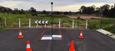
We establish and survey Ground Control Points where required to support the accuracy and spatial integrity of the project.
Independent Check Points
We survey independent Check Points to assess and verify the accuracy of the completed LiDAR dataset.
Drone LiDAR Data Acquisition
Flights are planned according to terrain, vegetation, required point density, survey accuracy, site conditions and the intended final outputs.
LiDAR Processing
Captured data is processed in-house, reviewed, classified and quality checked as part of our internal workflow.
Accuracy Verification
Our LiDAR accuracy is verified against independently surveyed Check Points rather than relying solely on manufacturer specifications. On a recent completed Drone LiDAR survey, the final dataset achieved a vertical RMSE (RMSEz) of 13 mm, with an average vertical difference of just 2.2 mm across 12 Check Points.
Actual project accuracy will vary depending on terrain, vegetation, GNSS conditions, flight parameters and survey control, but every project can be assessed against known ground positions to provide measurable and transparent accuracy results.
Final LiDAR Deliverables
The processed data is converted into practical survey and mapping outputs ready for use by clients, surveyors, engineers, planners, environmental consultants and other project stakeholders.
Drone LiDAR Survey Deliverables
Depending on the project requirements, LiDAR Drone Australia can provide:
-
3D LiDAR Point Clouds
-
Classified LiDAR Point Clouds
-
Ground classified Point Clouds
-
LAS and LAZ files
-
Digital Elevation Models — DEM
-
Digital Terrain Models — DTM
-
Digital Surface Models — DSM
-
Triangulated Irregular Networks — TIN
-
Contours
-
Ground surface models
-
Bare-earth terrain models
-
CAD-compatible data
-
GIS-compatible data
-
Orthomosaic imagery where required
-
Survey control information
-
Check Point results
-
LiDAR accuracy CSV reporting
-
Project-specific data formats
Our aim is not simply to provide a large file containing millions of points.
Our aim is to deliver usable, accurate information that supports real project decisions.
Drone LiDAR Topographic Surveys
Drone LiDAR is particularly effective for topographic surveying and terrain mapping, especially over large, difficult or heavily vegetated areas.
Unlike conventional aerial photogrammetry, LiDAR actively measures distances using laser pulses.
This enables the system to collect large numbers of three-dimensional measurements across the survey area and, under suitable conditions, obtain returns through gaps in vegetation to help identify the underlying ground surface.
For projects requiring detailed terrain information, this can make Drone LiDAR an extremely powerful mapping solution.
LiDAR Drone Australia provides Drone LiDAR topographic surveys for projects including:
-
Land development
-
Civil engineering
-
Infrastructure
-
Road projects
-
Rail corridors
-
Drainage
-
Flood studies
-
Waterways
-
Environmental projects
-
Forestry
-
Vegetation mapping
-
Mining
-
Quarries
-
Stockpile and volume analysis
-
Utility corridors
-
Pipeline routes
-
Transmission corridors
-
Large rural properties
-
Difficult terrain
-
Coastal areas
-
Construction planning
-
Preliminary design
-
Engineering investigations
Drone LiDAR Surveys Through Vegetation
One of the major reasons clients choose LiDAR is its ability to assist with terrain mapping in vegetated environments.
Traditional aerial imagery primarily records what can be seen from above.
LiDAR records individual laser returns, and some of those returns may pass through gaps in vegetation and reach the ground below.
Through careful classification and processing, these ground returns can be used to develop a bare-earth terrain model.
This makes Drone LiDAR highly valuable for areas containing:
-
Bushland
-
Forest
-
Scrub
-
Grass
-
Tree canopy
-
Uneven terrain
-
Gullies
-
Embankments
-
Creek lines
-
Difficult access
The achievable ground definition depends on factors including vegetation density, terrain, flight parameters and site conditions, which is why experienced LiDAR flight planning and processing are so important.
Drone LiDAR for Civil Engineering and Infrastructure
LiDAR Drone Australia provides high-resolution Drone LiDAR data for civil engineering, infrastructure and construction projects.
Drone LiDAR can rapidly capture detailed three-dimensional site information across areas that may otherwise require extensive conventional ground surveying.
Applications include:
-
Existing surface surveys
-
Preliminary design
-
Road upgrades
-
Highway projects
-
Drainage design
-
Earthworks
-
Cut and fill analysis
-
Corridor mapping
-
Construction planning
-
Progress mapping
-
Flood modelling
-
Infrastructure assessment
-
Route selection
-
Engineering design support
For large or complex sites, Drone LiDAR can provide engineers and project teams with an extremely detailed digital representation of the terrain.
Large Area Drone LiDAR Mapping
LiDAR Drone Australia has the capability to undertake large-area Drone LiDAR surveys covering hundreds or thousands of hectares.
Large projects require more than simply increasing the number of flights.
They require careful consideration of:
-
Survey control
-
Flight blocks
-
Data overlap
-
GNSS conditions
-
Terrain variation
-
Vegetation
-
Aircraft endurance
-
Point density
-
Data management
-
Processing
-
Accuracy verification
-
Consistency between flight areas
Our specialist approach allows large projects to be planned as a complete LiDAR survey rather than a collection of unrelated drone flights.
This helps maintain consistency across the entire project area.
Why Use LiDAR Drone Australia?
We Specialise in Drone LiDAR
LiDAR is not an optional extra added to a long list of drone services.
It is our specialist field.
Complete In-House Workflow
From surveying Ground Control and Check Points through to the final 3D Point Cloud, DEM, DSM, TIN and accuracy reporting, the project is managed internally.
Projects From 1 ha to Thousands of Hectares
We undertake detailed small-site projects as well as major large-area LiDAR surveys.
NSW and Australia-Wide Capability
Based in Sydney, we provide Drone LiDAR services throughout NSW, the Eastern States and across Australia.
Focus on Accuracy
Our work is centred around producing LiDAR data that is measurable, verifiable and fit for the intended project purpose.
Detailed Final Deliverables
We provide more than raw LiDAR data. We produce practical terrain and surface products that can be used across surveying, engineering, environmental, planning and infrastructure workflows.
Remote and Difficult Site Specialist
LiDAR Drone Australia specialises in operating in remote, rugged and difficult-to-access locations where conventional access can be challenging or impractical. Our field capability is supported by 4WD vehicles, trucks and an 8x8 amphibious vehicle, allowing our team to transport personnel, survey equipment and LiDAR systems into demanding terrain, including bushland, flood-affected areas, soft ground, steep country and isolated project sites. This specialist access capability enables us to undertake Drone LiDAR surveys in locations where others may be limited by terrain, access or site conditions.
The Difference Is Not only the Sensor. It Is the Process.
Buying a high-quality LiDAR sensor does not automatically produce a high-quality LiDAR survey.
Technology is only as good as the people planning, operating, processing and validating it.
The difference is understanding:
-
Where should the aircraft fly?
-
At what altitude?
-
At what speed?
-
What point density is required?
-
How should the survey control be established?
-
What happens when the terrain changes?
-
How does vegetation affect ground returns?
-
How should the data be classified?
-
How is the finished surface checked?
And most importantly:
How do you know the final data is accurate?
These are the questions that turn a Drone LiDAR flight into a professional Drone LiDAR survey.
Accuracy From the Ground Up
At LiDAR Drone Australia, we believe accuracy should not
simply be assumed.
It should be planned, measured and verified.
At LiDAR Drone Australia, accuracy is verified against surveyed ground positions rather than relying solely on manufacturer specifications.
On a recent Drone LiDAR survey, the completed LiDAR dataset was compared against 12 surveyed Check Points with known elevations.
The results achieved:
-
13 mm Vertical RMSE (RMSEz)
-
2.2 mm Average Vertical Difference
-
12.9 mm Standard Deviation
-
10 of 12 Check Points within ±20 mm
-
Maximum observed vertical difference of 25.3 mm
These results demonstrate the level of vertical accuracy that can be achieved through the combination of quality LiDAR equipment, appropriate flight planning, GNSS positioning, survey control, processing and independent accuracy verification.
Accuracy Is More Than the LiDAR Sensor
A high-quality LiDAR sensor is only one part of producing an accurate survey.
Final accuracy is influenced by factors including flight altitude, aircraft speed, LiDAR configuration, GNSS conditions, terrain, vegetation, Ground Control, Check Point distribution and data processing.
For this reason, LiDAR Drone Australia can establish surveyed Ground Control Points and Check Points and compare the completed LiDAR surface against known surveyed elevations.
This provides our clients with measurable project accuracy based on the finished dataset—not simply a theoretical sensor specification.
Actual accuracy will vary between projects according to terrain, vegetation, flight parameters, survey control, GNSS conditions and the required deliverables. The accuracy figures above relate to the vertical results achieved on a completed LiDAR survey.
Drone LiDAR Survey NSW
LiDAR Drone Australia provides specialist Drone LiDAR surveying throughout NSW, including Sydney, Greater Sydney, regional NSW and remote and difficult project locations.
Our work can support projects involving:
-
Engineering
-
Surveying
-
Civil construction
-
Environmental management
-
Forestry
-
Infrastructure
-
Mining
-
Land development
-
Flood modelling
-
Terrain analysis
-
Government projects
-
Large private properties
Our mobile capability allows us to undertake projects throughout the state where Drone LiDAR provides a safer, faster or more practical method of collecting detailed three-dimensional terrain data.
Drone LiDAR Surveying Australia-Wide
Although based in Sydney, our capability extends well beyond NSW.
LiDAR Drone Australia undertakes Drone LiDAR projects across the Eastern States and throughout Australia, particularly where specialist LiDAR capability is required for large, technically demanding or remote projects.
From 1 ha detailed survey through to a project spanning thousands of hectares, we can plan the data acquisition, survey control, processing and deliverables as one complete workflow.
Need a Drone LiDAR Survey?
If your project requires accurate Drone LiDAR surveying, LiDAR mapping, topographic LiDAR data, terrain modelling, 3D Point Clouds, DEMs, DSMs or TIN surfaces, speak directly with a company that specialises in the technology.
LiDAR Drone Australia
Dedicated Drone LiDAR Specialists
From Ground Control to Final Deliverables — All In-House.
NSW | Eastern States | Australia-Wide






_edited_edited.jpg)


Drone LiDAR Survey Projects Across Australia
Large-Area LiDAR Survey – Regional NSW
Case Study – Macquarie Marshes Drone LiDAR Survey
LiDAR Drone Australia successfully completed a challenging Drone LiDAR survey covering approximately 20 km x 0.5 km through the Macquarie Marshes in Central NSW.
Access was extremely difficult due to major track washouts, severe erosion, extreme mud, numerous water crossings, surface water, dense reeds and vegetation, extreme heat and numerous snakes.
Our team utilised a fully equipped 4x4 vehicle and Tinger 8x8 amphibious vehicle to safely access all required survey areas.
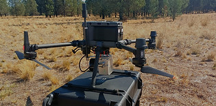
The survey was undertaken using our DJI M350 RTK equipped with the GeoSun GS-260X LiDAR sensor, supported by Ground Control Points (GCPs) and Check Points referenced to GDA2020 / MGA Zone 55 with AHD heights.
The survey achieved a high-density point cloud of approximately 750 points/m², producing detailed 3D point cloud data, TINs, Digital Surface Models (DSM) and Digital Terrain Models (DTM) across this remote and extremely challenging environment.

Vegetation & Bare-Earth LiDAR Survey
Case Study – 3,800 ha Drone LiDAR Survey, NSW National Park
LiDAR Drone Australia successfully completed a large-scale 3,800-hectare Drone LiDAR survey within a major NSW National Park region. The project was undertaken to provide detailed topographic and terrain data to support the planning and design of significant road improvement works throughout the National Park.
The survey presented a number of logistical and operational challenges, with dense vegetation, steep inclines, rugged terrain and difficult access across large sections of the project area. To safely reach the required survey locations, our field team utilised a fully equipped 4x4 support vehicle together with our Tinger 8x8 amphibious all-terrain vehicle, allowing us to operate in areas that would otherwise have been extremely difficult to access.
Drone LiDAR was particularly suited to this environment, providing the ability to capture detailed terrain information across heavily vegetated and steep areas while significantly reducing the need for extensive ground-based survey access.
The completed survey produced high-density 3D point cloud data, Triangulated Irregular Networks (TINs), Digital Surface Models (DSM) and Digital Terrain Models (DTM). These datasets provided detailed information on the existing terrain and surface conditions, supporting the assessment, planning and design of major road infrastructure improvements within this challenging National Park environment.

Environmental LiDAR Mapping Project
Case Study – 6,700ha Drone LiDAR Survey, Northern Queensland
LiDAR Drone Australia successfully completed a large-scale 6,700-hectare Drone LiDAR survey across private property in Northern Queensland. The survey was undertaken to provide detailed terrain information to assist with determining water flow, drainage patterns and surface movement across the region.
The project presented significant access challenges due to dense vegetation, extensive wetland areas, soft ground conditions and difficult terrain. Our field team utilised a fully equipped 4x4 support vehicle together with our Tinger 8x8 amphibious all-terrain vehicle, allowing us to safely access remote and waterlogged areas throughout the property.
Drone LiDAR was ideally suited to the project, providing detailed elevation data across heavily vegetated and wetland environments. The completed survey produced a 3D point cloud, TINs, Digital Surface Model (DSM), Digital Terrain Model (DTM) and accurate contour mapping.
The resulting datasets provided the client with a detailed understanding of the property's terrain and hydrology, supporting the assessment of water movement and flow across this extensive Northern Queensland landscape.

Road Corridor LiDAR Survey
Case Study – M12 Motorway Drone LiDAR & Photogrammetry Survey, Sydney
LiDAR Drone Australia undertook a significant Drone LiDAR and Photogrammetry survey for Sydney’s M12 Motorway project, covering the approximately 16 km motorway corridor during the early planning stages of this major infrastructure development.
In addition to the proposed M12 alignment, our survey works extended to surrounding road networks, including sections of the M7 Motorway and The Northern Road, providing comprehensive existing-condition data to support early-stage planning and design.
The combined LiDAR and high-resolution Photogrammetry survey produced detailed 3D point cloud data, aerial imagery, orthophotography and topographic information, delivering an accurate representation of the existing terrain, road corridors and surrounding landscape.
This project demonstrated the effectiveness of combining Drone LiDAR and Photogrammetry for large-scale linear infrastructure and motorway projects, providing rapid, detailed and accurate survey data across an extensive transport corridor.

Infrastructure LiDAR Survey – NSW
Case Study – 12 NSW Cemetery Drone LiDAR Surveys
LiDAR Drone Australia successfully completed a major infrastructure surveying program involving 12 cemetery sites across NSW, surveyed consecutively to support future planning, design and asset management.
Each site was surveyed using high-density Drone LiDAR, with all data referenced to GDA2020 and AHD. Ground Control Points (GCPs) and independent Check Points were established across the sites to support survey accuracy and quality assurance.
The surveys achieved an impressive 3D point cloud density of over 700 points per square metre, providing highly detailed representations of the existing terrain, structures and surrounding environments.
Final deliverables included high-density 3D point clouds, TINs, Digital Surface Models (DSM) and Digital Terrain Models (DTM), providing comprehensive datasets for the future planning and development of all 12 cemetery sites.

Let’s Talk About Your Project
Have a Drone LiDAR, Photogrammetry or Aerial Survey project coming up?
Give us a call — we’re always happy to have a chat about your project, answer your questions and discuss the best way to get the results you need.
📞 0489 056 000
📞 0457 777 037
You’ll speak directly with our team — no call centres, no complicated process, just practical advice from people who understand drone surveying.
Whether your project is large or small, local or remote, we’d be happy to hear from you.